


Thursday 10 August 2017
| Distance (km) | 27 kms | |||
| Distance (time) | 7.5 hrs | |||
| Climb / Descent | 880m / 900m | |||
| Hard / Soft surface | 40% / 60% | |||
| Landscape |
|
|||
| Weather |
|
|||
|
|
||||
|
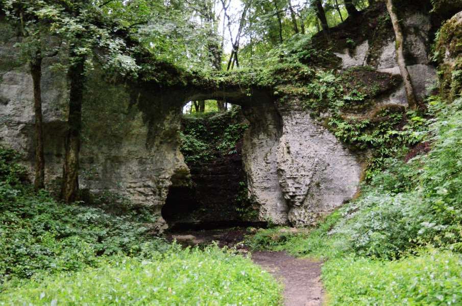
The first real Jura day and we're eager! After my knee problems kast week and yesterday's 7 km test walk we are confident that everything will be fine today. It rained the whole night and it was still raining when we got up this morning. But after a 50 minutes drive to St.Hippolyte and the bus to Montbeliard we already noticed the cloud coverage breaking and after the loooong bus drive to Dasle it stops raining. Good! For a change it doesn't immediately climb like a rocket when we leave Dasle. Not that it's flat, but it just gently climbs through the fields. The track is a bit muddy, not really a surprise. We swiftly reach Vandoncourt so that we can prepare for the first real (little) climb of the day (out of 3). Along a brook we climb to a beautiful natural rock bridge: Pont de Sarrazin. That is where the tourist track ends and so the last bit up is a slippery muddy path with a couple of switchbacks. Once at the summit we have to follow a gravel road and that is quite practical because that means it is at least not muddy. The road is flat and pretty straight so we make good distance. Until now we were wearing our rain coats just in case a sudden gust of wind would shake quite some water out of the trees. But that doesn't seem to happen and when we leave the forest we decide to pack the rain coats. We now enter the fields where the gravel road slowly turns into a tarmac road before ending at the larger D148. Along this road we arrive in Abbévillers that we walk out of as fast as we entered it. The road out of the village slowy descends and becomes a gravel road again. At the edge of the forest it starts to descend more seriously and the path is getting rocky. Unfortunately the rocks are very slippery and so we slip and slide into the valley of the Doue. Down in the valley we get a moment of rest as we now follow the stream on a gravel road to La Papeterie, not much more than a restaurant that clearly is not open yet. Climb number 2 is on now: a steep and pretty straight path to the French-Swiss border. The first part of the climb is a steep forest track with quite some loose rocks but not too bad. The last bit to the border is barren rock and again very slippery. And the border is not even the highest point: the GR5 turns right in order to follow the border and just keeps climbing. At the highest point there is a border crossing. It's really nothing: a narrow road (tarmac in Switzerland, gravel in France - coincidence?) and a sign reading that everybody passing the border here should be in the possession of a valid identification and no taxable goods. That's it... The track now descends into a narrow little valley. There are some trees over the path, which is a bit of a challenge. But it's a nice walk lik this. Ha, too bad, because suddenly we have to turn left out of the valley taking very long steep stairs up the side of the valley. Why of why? We struggle our way up after which the tracks undulates. At some point we're supposed to squeeze ourselves in between blackberry bushes with thorns and a barb wire fence, which is practically impossible. We complain to ourselves and are happy to walk back into the forest on a far easier track. The route leaves the border again whilst crossing a pasture. Fortunately without cows this time. After the pasture we slowly descend along a narrow tarmac strip into Villars-lès-Blamont. We zig-zag through the village and prepare ourselves for the 3rd climb of the day (we didn't count on the stairs along the border) to Mont Lomont. The first part follows a tarmac road turning into a forest track. The climb is not so difficult and once at the summit we pass a view point and also the remains of a late 19th century defense work that was used in the first world war. We remain on top of Mont Lomont until the point where the GR5 joins the the Grand Traversee du Jura (GTJ). Here the road briefly descends, then climbs a bit again towards a farmhouse before continuing the descent. Only the last bit to Chamesol is seriously descending and this is where my knee starts bothering again. Until now everything was fine, but especially the steep part through Chamesol is painful. After the village it is flattish again until the D121 that we have to cross. We now follow a track towards the forest and in the forest it again descends quite steeply over a very rocky path. I'm trying to walk in such a way that my knee bothers me the least (with stretched leg, with a bended knee) but it doesn't really work. Fortunately we arrive in St.Hippolyte in one piece where the road flattens out. And walking on the flat is not a problem... We leave the GR5 in order to reach the post office next to the bridge, that is where we parked the car. It's almost 20:00 hours and we still have to drive back to Morteau where our tent is. |
 |
|||
|
|
||||